

This is a developing situation and information may change. We’ll update this article as more information becomes available. The most recent information will be updated at the top of the article, with the earlier reports below.
Editor’s note: for our latest storm coverage for Feb. 27, see our latest article here.
2/26/23 9:39 p.m. — The South Coast Fire Protection District reports that Fish Rock Rd. is open again. Approximately 543 trees fell on the road in the most recent storm. The district is advising that drivers use an alternate route due to the amount of snow and debris still present and that only 4-wheel drive vehicles with chains should attempt the road.
Eel River Charter School in Covelo will start at 10:15 a.m. on Monday, Feb. 27 due the weather.
Out of abundance of caution for the safety of vendors and customers, the Laytonville Farmers Market is canceled for Monday, Feb 27.
Redwood River Resort in Leggett suffered “much more damage than anticipated” in the first round of winter storms this past week. The resort is closed to the public until further notice and reservations will be canceled for the time being. Contact [email protected] for more information (phone lines are not working).
2/26/23 4:00 p.m. — As of 1 p.m., the winter storm advisory has expired for Mendocino County per the National Weather Service Eureka (NWS Eureka). As of 3:15 p.m. Sunday, Feb. 26, NWS Eureka forecasts that “the heaviest snow is expected during Monday morning with showers persisting through Tuesday night.”
Exact snow levels between 1,000 and 2,000 feet elevation are unknown, but are expected to vary based on valleys and ridges. The biggest concern for safety are mountain passes along highways due to heavy snowfall which may create blizzard conditions on Monday morning. Per NWS Eureka “for highway passes in the 1,500 ft. region (the 101 corridor from Leggett to Willits, highway 175, and highway 20) difficult to nearly impossible travel conditions are likely Monday morning.
Power outages are anticipated and restoration will be “possibly difficult due to the aforementioned travel impacts” meaning multiple day outages are possible according to NWS Eureka. As mentioned below, a wind advisory will be in effect for portions of the interior, including Potter Valley, Willits, Leggett, and Laytonville, from 9 p.m. this evening. Additionally, a winter storm warning starts at 10 p.m. tonight for the entire State Route 101 corridor and Round Valley, and remains in place until 4 p.m. Tuesday, Feb. 28. Check out the forecast below for further details on what you can expect tonight.
MENDOCINO Co., 2/26/23 — After enjoying one calm day of weather, storm conditions have returned to Mendocino County this morning, Sunday, Feb. 26. Today through Tuesday, Feb. 28, the region will experience two storm systems that will bring rain, high wind, isolated thunderstorms, hail, and heavy mountain snow to parts of the county depending on elevation and microclimate.

There is a mix of winter storm advisories, warnings, and wind advisories either currently in place, or going into effect later today. We’ve put together an overview of what’s to still come, and included some additional resources at the end of the article — plus we’ll keep you updated throughout the storm, which is expected to last until Feb. 28. We also have a winter weather info guide we recommend you bookmark.
NWS Eureka is collecting your snow reports during this storm with the amounts, time, location, and elevation — you can submit snow reports here. If you’re interested in an overview of the statewide impacts of these storms from a meteorological perspective, we recommend checking out Daniel Swain of Weather West, who has been sharing information throughout these major weather events.
Road conditions and power outages
State Route 1 remains fully closed from State Route 271, just west of Highway 101, to Cottaneva Creek just north of Rockport, due to dangerous road conditions, including downed trees and power lines. There is no estimated time of reopening. Additionally, a portion of State Route 271 is closed from Reynolds Overcrossing, south of Piercy, to State Route 101, and there is no estimated time of reopening. After a long closure, Highway 101 is fully open throughout the county as of this morning.

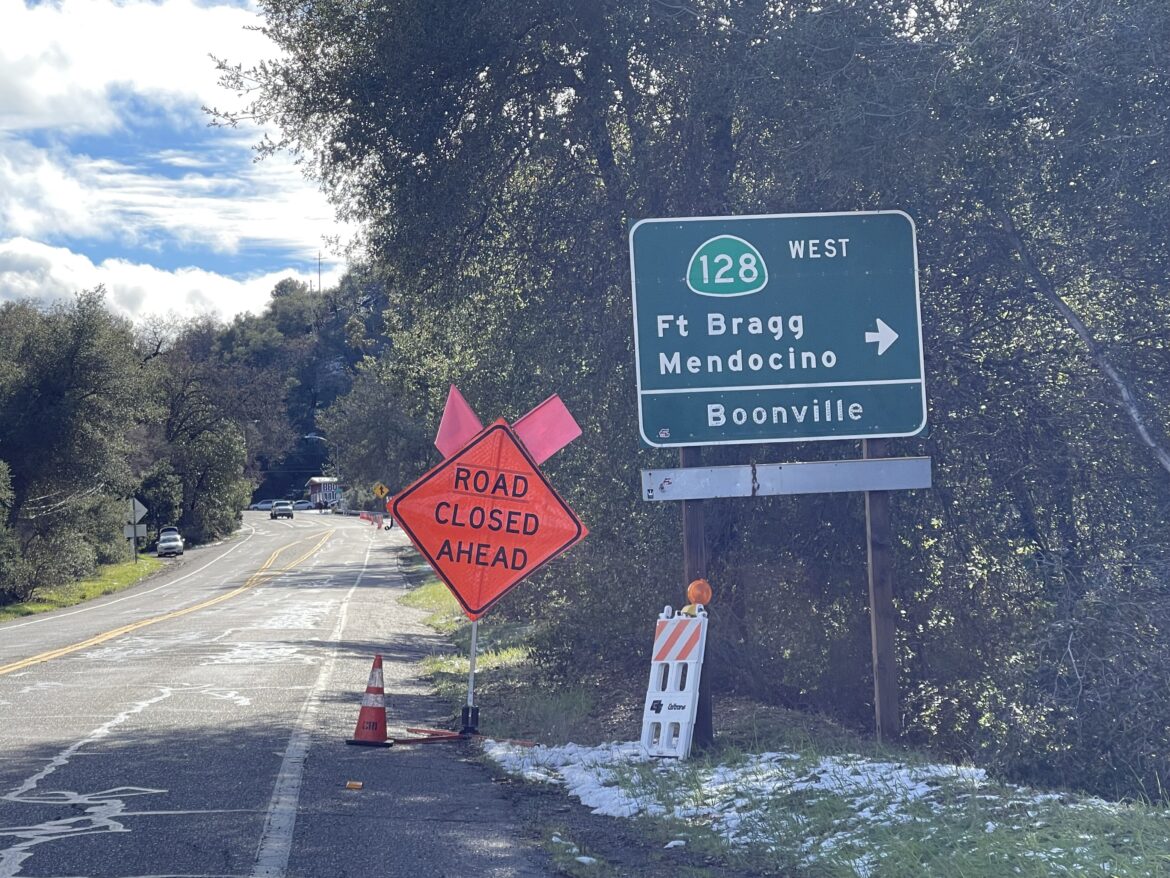
In the southern part of the county, State Route 128 remains closed due to hazardous conditions from Robinson Creek in Anderson Valley to the Sonoma County line near Cloverdale. State Route 175 is also closed from Buckman Dr. east of Hopland to State Route 29 also due to snow. There is no estimated time of reopening for either of these closures. Drivers can track state road conditions here.
Additionally, the South Coast Fire Protection District asks that people not travel on Fish Rock Road today while fire crews work to improve road conditions. Residents of this part of Point Arena have been unable to leave the mountainous area due to treacherous roads.
Over 1,570 PG&E customers are without power in the county, with the largest outages in Leggett, Laytonville, Round Valley, Anderson Valley, Hopland, and unincorporated areas of western Ukiah. For many customers, it could be another two days before power is restored due to road and weather conditions, which, according to PG&E, can make it challenging for PG&E crews to access areas or work safely. Monitor outage conditions here.
What to expect on the coast for Feb. 26
Coastal areas will see rain, between a tenth and a quarter of an inch. Point Arena will also see breezy conditions with gusts up to 29 mph. Coastal high temperatures will average between 45 and 52 degrees. Tonight, rain showers will continue along the coast, with up to half an inch or less of precipitation in the forecast. Westport will see breezy overnight conditions, with wind gusts up to 21 mph. Low temperatures along the coast will range from 38 to 42 degrees in the south part of the coastal county.
What to expect inland for Feb. 26
Inland areas will experience the biggest storm impacts today: Leggett, Laytonville, Willits, Covelo, and Potter Valley are under a winter weather advisory until 1 p.m.. According to the NWS, a winter weather advisory means areas may see one or more of the following: snow of 3-5 inches in 12 hours, a half inch or more of sleet, freezing rain with sleet/snow, and/or blowing snow. The areas under the advisory may receive between a tenth and a quarter inch of rain today, with some areas, including Laytonville, Leggett and Willits, experiencing gusty wind conditions. Highs will be in the mid-40 degrees.
Tonight conditions will be a mix of rain and snow. A wind advisory will be in effect for portions of the interior, including Potter Valley, Willits, Leggett, and Laytonville, from 9 p.m. this evening, through 8 a.m. Monday. These areas may experience southwest winds 20 to 30 mph with gusts up to 60 mph, particularly on ridgetops leading to blizzard-like conditions according to the National Weather Service Eureka (NWS Eureka).
Additionally, a winter storm warning starts at 10 p.m. tonight for the entire State Route 101 corridor and Round Valley, and remains in place until 4 p.m. Tuesday, Feb. 28. Leggett and Laytonville will see snow after 10 p.m. and rain after 4 a.m. Monday, with accumulations up to 2 inches and more in elevations over 1,500 feet. Willits, Round Valley, and Potter Valley, will see a mix of rain and snow overnight with snow accumulation around one inch in lower elevations.
Further south, Ukiah and Hopland will see rainy conditions today with under a quarter of an inch of precipitation. Highs will average 49 degrees. Tonight, these communities will also be under the winter storm warning. Ukiah may see a mix of rain and snow overnight with under half an inch of snow accumulation possible. Temperatures will be at or below freezing.
Anderson Valley is free of any warnings or watches today and tonight. Today will be rainy with the possibility of gusty winds up to 20 mph. Tonight will be mostly cloudy with a 50 percent chance of showers. The high will be 49 degrees and low 32 degrees.
Mendocino County’s many microclimates mean the weather conditions may vary based on your location, especially by elevation. You can check for the specific forecast for your neighborhood and on current road conditions as they develop.
Information is changing rapidly, and we’ll be keeping you updated on current conditions throughout the next several days. Although local agencies are preparing for the storm, emergency resources are likely to be stretched thin — if you can avoid travel, please stay off the roads for everyone’s safety.
You can read more about the storm’s original forecast in our previous article about this storm, and be sure to bookmark our winter weather information guide. There are additional resources included at the bottom of the article so you can check the exact conditions in your area.
Mendocino Voice Winter weather resources:
- Our guide for winter weather emergency and preparedness info — we recommend you bookmark this
- Check your specific forecast at this link along with the National Weather Service advisories and warnings, as well as their Facebook page and their Twitter page
- Check the CalTrans QuickMap for current road closures or call 1-800-GAS-ROAD
- Check for current accidents at the CHP traffic update page
- Caltrans traffic cameras can be seen here, and here are the PG&E cameras
- You can also check out the Weather Underground to look for weather stations in your area
- Check the PG&E current outage map to find or report power outages
- NWS has flood stage predictions here; and you can find USGS current streamflow information here
- NWS is seeking snowfall reports, and you can submit them to this website.
- We recommend meteorologist Daniel Swain’s Weather West Blog as a good place to find more in-depth current weather analysis