

This is a developing situation and information may change. We’ll update this article as more information becomes available. The most recent information will be updated at the top of the article, with the earlier reports below.
3/28/23 1:15 p.m. — U.S. Route 101 is open again after a two hour closure due to road conditions. Drive safely!
Sherwood School is releasing students early. Children can be picked up by parents/guardians at Willits High School.
3/28/23 11:00 a.m. — The National Weather Service Eureka (NWS Eureka) has issued a flood advisory until 1:30 p.m. today, Tuesday Mar. 28 for the entire county. According to NWS Eureka “Minor flooding in low-lying and poor drainage areas. Overflowing poor drainage areas. Ponding of water in urban or other areas is occurring or is imminent.” As of 9:36 a.m. the region has seen between 0.5 to 1.5 inches of rain. A winter weather advisory remains in place for the northern interior until 11 a.m. Wednesday Mar. 29.
A rock slide has been reported in the southbound lane of U.S. Route 101 and Nelson Ranch Rd. near Saechao Strawberry Farm. Reports of downed trees are also being reported on State Route 1 in the Albion area. Please drive carefully. You can monitor state road conditions here.
Solid Waste of Willits drivers are running into dangerous road conditions due to rain and snow. As a result, drivers are delaying some pickups. The service asks that customers be patient.
3/28/23 10:17 a.m. — U.S. Route 101 is closed in both directions at Rattlesnake Summit, north of Laytonville, due to snow by Caltrans. No estimated time of reopening has been provided.
MENDOCINO Co., 3/27/23 – After a taste of spring-like weather this past weekend, portions of inland northern Mendocino County will experience another bout with wintry weather. Starting this evening, Monday, Mar. 27, portions of the county can expect a mix of rain, snow, and windy conditions, which may lead to treacherous road conditions and flooding.
We’ve put together an overview of what’s to still come, and included some additional resources at the end of the article. We also have a winter weather info guide we recommend you bookmark, and information about FEMA assistance, CalFresh replacements, and other storm aid on our website.
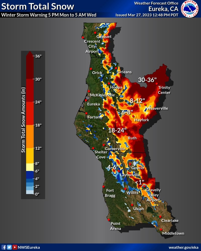
A mix of rain and snow will blanket portions of the county
While conditions have been somewhat pleasant across the region today, starting this evening the weather will bring significant precipitation in the form of snow and rain to parts of the U.S. Route 101 corridor in north county and Round Valley.
The National Weather Service Eureka (NWS Eureka) has issued a winter weather advisory for areas including Willits, Covelo, Redwood Valley, Laytonville, Leggett and Piercy starting at 5 p.m. Monday Mar. 27 through 5 a.m. Wednesday Mar. 28.
NWS Eureka forecasts that areas above 1,500 feet may see snow, with elevations 2,000 feet or higher receiving a possible 2 to 7 inches of snow, and possibly more in backcountry regions. Laytonville is forecast to receive between 3 to 5 inches overnight into Tuesday morning.
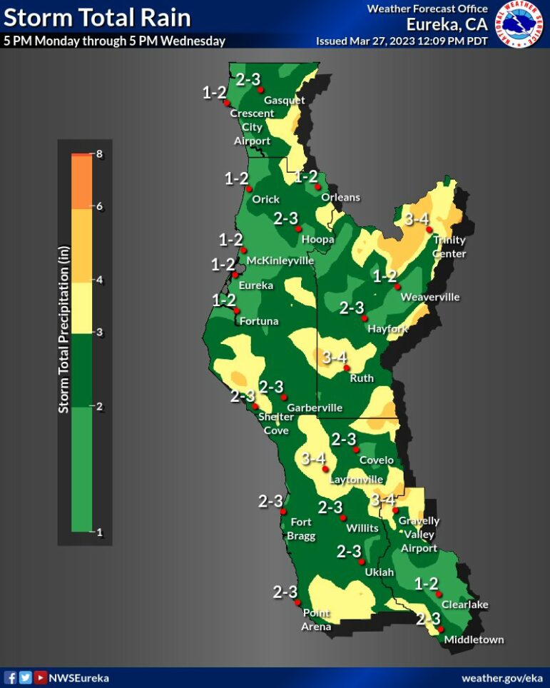
Rain wise, the entire county is expected to see rain Monday evening through Wednesday. Lower elevations will see between 2 and 3 inches of precipitation from 5 p.m. Monday Mar. 27 through 5 p.m. Wednesday Mar. 29. Some areas of the county may see thunderstorms on Wednesday.

The return of heavy rain and snow to the region is likely to create hazardous travel conditions especially along State Route 162 south of Covelo and Highway 101 north of Willits. NWS Eureka forecasts that “travel could be very difficult to impossible” in those areas, including in Humboldt, Del Norte and Trinity counties.
As of Monday afternoon, rainfall amounts aren’t expected to cause major flooding in the usual flood zones, including the Navarro River in Navarro and the Russian River in Hopland. However, conditions may change. River forecast data can be viewed here.

High winds could result in downed trees and power outages countywide
High winds will usher in the storm across the county, and are likely to bring more downed trees and power outages. NWS Eureka has issued wind advisories for the entire county starting at 6 p.m. on the coast and 8 p.m. inland tonight, Monday Mar. 27. The advisories will expire at 5 a.m. Tuesday, Mar. 28. Parts of the county may experience strong winds between 25 and 35 mph with gusts up to 55 mph.
The high winds are expected to blow around unsecured objects, such as patio furniture. However, the greatest threat are trees. The ground across the county is already heavily saturated from rain and snow, meaning root systems may be compromised. As a result, high winds can cause tree roots to lose grounding in the soil, resulting in downed trees, according to AccuWeather senior meteorologist Alex Sosnowski. High winds can also bring down power lines and poles.
Conditions may vary widely across North Coast microclimates, and on your travel routes, so we’ve included a list of useful resources to keep you updated at the bottom of this article. You can check for the specific forecast for your neighborhood and on current road conditions as they develop.
If you’re going to travel through regions under winter weather warnings, keep an extra flashlight, food and water in your vehicle in case of an emergency and drive safely. Use extra caution when driving, especially high profile vehicles. Find tips on staying safe during high wind events here.
Mendocino Voice Winter weather resources:
- Our guide for winter weather emergency and preparedness info — we recommend you bookmark this
- Check your specific forecast at this link along with the National Weather Service advisories and warnings, as well as their Facebook page and their Twitter page
- Check the CalTrans QuickMap for current road closures or call 1-800-GAS-ROAD
- Check for current accidents at the CHP traffic update page
- Caltrans traffic cameras can be seen here, and here are the PG&E cameras
- You can also check out the Weather Underground to look for weather stations in your area
- Check the PG&E current outage map to find or report power outages
- NWS has flood stage predictions here; and you can find USGS current streamflow information here
- NWS is seeking snowfall reports, and you can submit them to this website.
- We recommend meteorologist Daniel Swain’s Weather West Blog as a good place to find more in-depth current weather analysis
Sarah Stierch covers wildfires, breaking news, and more for The Mendocino Voice. You can follow Stierch on Twitter and learn more about her work and donate to her directly at here. Contact Stierch at [email protected]. The Voice maintains editorial control and independence.