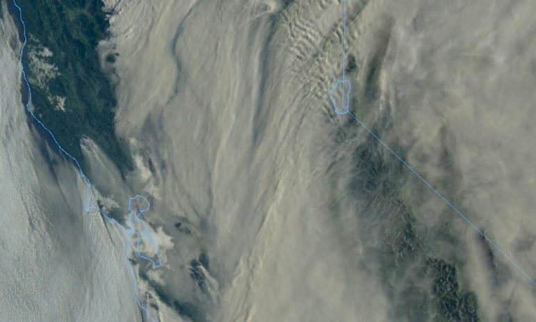
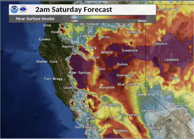
MENDOCINO Co., 8/22/20 — Haze, smoke, and the distinct smell of a burning wildfire arrived in much of Mendocino County over night, as wildfires ravage the northern half of the state. There are currently no substantial fires in Mendocino County. And though the smoke has sparked fears that the fires may be in the county, the smoke is almost entirely from out of county — the scale of these fires is simply so immense that the smoke may reach to Chicago.
Smoke is blanketing much of the state after a week of rapidly growing lightning fires that have consumed more than 771,000 acres in California, and as the fires continue to blaze and with little rain in sight, the smokey skies may remain. So far, Mendocino County has escaped much of the brunt of the smoke, which has largely spread eastward as many fires now in that direction, and the clear skies have meant that massive pyrocumulus clouds from the distant fires can be seen from many parts of Mendo. As of now, in Mendocino County, air quality is forecasted to be from “good” to “moderate” over the weekend. However, the Mendocino Air Quality Control District only maintains a handful of air quality sensors, and the picture of air quality provided is often sketchy.
Many Mendocino County residents have experienced living with wildfire smoke before, but this year the COVID-19 pandemic is also surging in the county, and like the novel coronavirus, wildfire smoke can cause respiratory damage, or even potentially some similar symptoms.

The Mendocino County Air Quality Management District is not predicting a significant decrease in air quality through the weekend, but residents should be prepared in case the situation changes or for possible smoky skies later in the fire season. However, air quality may be in the unhealthy ranges for other portions of Northern and Central California. Additionally, another potential round of thunderstorms may begin on Sunday (read more about the fire weather we’re having here).
If it is smokey, staying inside is possible is the best option, and otherwise using a N95 mask — however due to the novel coronavirus the availability of N95 masks remains limited.
Here’s some additional information about how to check the air quality near you, and tips for dealing with wildfire smoke.
- Mendocino Air Quality Management District
- AirNow.gov Fires and Smoke Map
- Environmental Protection Agency’s site
- National Weather Service
- Link to sign up for air quality notifications
- Tips from the CDC about wildfire smoke and COVID-19
- Tips from the CDC about wildfire smoke in general
- How to build your own cheap air purifier
- Article published during the Mendocino Complex Fires with tips about how to stay safe when the air quality is poor (note: N95 masks are not currently available for pick up)
Here’s a press release from the Air Quality District covering air quality in the county from August 22 through August 24:
August 21, 2020 6:30 PM: The Air District is monitoring potential smoke impacts to Mendocino County from the wildfires in Northern California. Smoke impacts are NOT forecast for Mendocino County over the weekend. Currently air monitors show particulate matter concentrations in the “Good” to “Moderate” range in Ukiah, Fort Bragg and Willits.
Based on meteorological forecast of west northwest winds, expect smoke to remain outside of Mendocino County to the east and south. The Bay Area, San Joaquin Valley and Sacramento Valley areas will continue to experience smoke impacts reaching the “Unhealthy” range.
Hurricane Genevieve is generating a tropical wave moving north bringing small but more lightning and thunderstorms to Northern California early next week.
Mendocino County Air Quality Management District continuously monitors the air quality, reporting particulate matter and ozone concentrations hourly to our website: www.mendoair.org. In the sidebar on the right of our webpage (scroll down if using a mobile device), under “Air Quality for Mendocino”–Click Here for current conditions, forecast, and email alerts. For additional information, click on an air quality index range, or the colored tabs below the map.


