MENDOCINO Co., 8/5/18 — The Mendocino Complex continued to grow today, and has now attained the grim distinction of being fourth largest wildfire in California history — as of this afternoon it stood at 266,982 acres. Of course the Mendocino Complex is composed of two distinct wildfires, the River Fire and the Ranch Fire, and conditions on the two fires are now disparate — the River Fire is nearly totally encircled, and the situation there has come increasingly under control, while conditions on the Ranch Fire have remained extremely difficult, and that fire continues to grow dramatically.
The increased control of the River Fire, which is at 48,663 acres and 58% contained, has allowed the re-opening of Hwy. 20 from U.S. Route 101 to Hwy. 29 — Hwy. 29 has also been re-opened. Hwy. 20 is also open from Hwy. 53 to Williams, and so travel between Ukiah and Williams is now possible by looping to the south of Clear Lake.
Even counted by itself the Ranch Fire, now at 218,319 acres and 23% containment, is now the seventh largest in the history of the state. Together the fires have claimed at least 68 residences and 62 other structures, though this count is also likely to grow, as fire intensity subsides and CalFire teams have a chance to investigate and document the destruction.
At “virtual” community meeting held this afternoon Charlie Blankenheim, CalFire operations section chief, gave a thorough description of fire conditions and firefighting efforts today. He described today as a “real good day” on the River Fire, explaining that the southern section of the fire is nearly totally tied in and they are mopping up there and area nearly ready to move out. (Watch that video here:)
Scotts Valley has also been tied in, and on the Mendocino side lines have been built and two seperate firing operations are proceeding, planning to meet together and complete the encirclement of the fire. Many residents of Ukiah have noted flames and smoke burning on the western side of the hills, visible from Ukiah — CalFire has confirmed that these are not wild flames, but planned controlled burns meant to tie together the containment lines. As such, these flames pose no serious threat to the Ukiah Valley.
This backfiring operation will continue over night, and CalFire plans on burning a couple thousand acres of land, meaning that smoke and flames might once again be visible — but again, they are not a threat, but instead part of the containment operations.
The success in containing the northern section of the River Fire, and the containment and burned out nature of the southeastern flank of the Ranch Fire, finally allowed the re-opening of Hwy. 20 today, after more than a week of closure.
But the Ranch Fire is another story and remains, in the words of Blankenheim “active” and “dynamic.” The oldest section the fire, along Hwy. 20 and near Potter Valley has burned out, has strong containment lines around it, and has been “pretty much mopped up.” But the fire has burned from there at least 35 miles to the east and continues to threaten communities along the northern and northeast shore of Clear Lake. Also threatened are communities in the National Forest around Lake Pillsbury, and in western Colusa County, as far north as Stonyford.
In Lake County firefighters have done a lot of work to build strong lines north of the communities of Nice, Lucerne and Clearlake Oaks, and have also done work to prepare the communities themselves for structure defense. Today they “went direct” on the fire, that is, fighting it directly with tanker drops, helicopter drops, and ground crews. Overall firefighters are making a huge effort to keep the fire in the hills above these communities, though.
Tonight they plan to continue going direct against the fire, to keep it out of the lake shore communities, though they are being challenged by frequent spotting. On a happy note, the success on the River Fire have meant that more resources and especially aircraft have been devoted to shoring up the lines on the south side of the fire to protect Nice, Lucerne and Clearlake Oaks.
To the east the fire actually grew into the area burned out by the Pawnee Fire, where firefighters have made good progress at stopping it. The fire has grown around Indian Valley Reservoir where firefighters have made good progress towards containing it, but has continued to move north. A dozer line has been built to protect the communities in western Colusa, including Lagoda and Stonyford.
Still there remains a chance that the fire could jump these lines or spot across overnight.
To the north the plan is to build dozer line north from Stonyford and then bear east back into the National Forest — but resources actually in the forest remain scarce, and the land is extremely rugged. The fire could continue to grow north into the Mendocino National Forest for some time. Until now the focus of the firefighting efforts have been control the fire closer to communities and to provide structure defense. It’s only now that firefighters are turning their efforts to containing it within the huge expanse of the forest. There the plan is to build containment lines from around Mid Mountain Rd., above Potter Valley and out to Lake Pillsbury then out to the Eel River, and use the Eel as one of the containment lines for the fire.
Said Blankenheim, “They were kind of futile at time, it felt like nothing was working, things are starting to come together now at little bit. We still have a lot of challenges…we feel like we’re kind of getting ahead of the game on the whole bottom of the fire.”
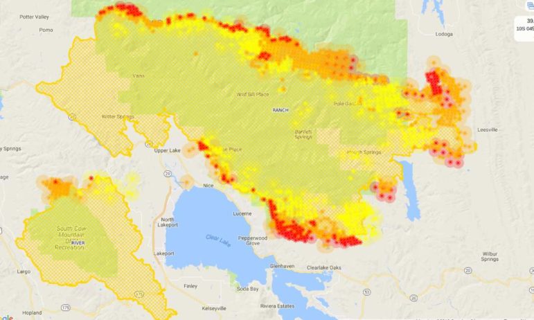
Below is a map of the Complex generated with VIIRS and MODIS satellite data. The map is unevenly updated, with some sections updated early this morning and some around midday, a more accurate map will be avaliable early tomorrow morning, and depends on when the satellites pass overhead and where their sensors are pointed:

A map of the Mendocino Complex incorporating satellite data of hot spots, on Aug. 5
Other details
There have been several other announcements and new information brought forth today, and we’re going to try to cover some of it here.
Lake County announced that government offices and the superior court would be open tomorrow:
The River and Ranch Fires began Friday, July 27, and continue to threaten portions of Lake County. Consequences have been widespread, including the closure of most Lakeport-based County offices and the Lakeport branch of the Superior Court for the full week of July 30.
Monday, August 6, all Lakeport-based County offices and the Lakeport Branch of the Superior Court will reopen. Offices in all areas of the County no longer under Mandatory Evacuation will also resume business.
County government and Court leaders have undertaken considerable efforts to ensure the Lake County Courthouse building and other County offices are ready for the resumption of regular duties.
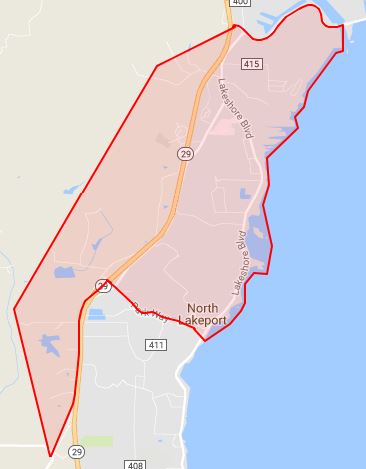
The evacuation order was reduced in North Lakeport:
The evacuation order for the North Lakeport area east of Hill Road has been reduced to an advisory. Residents north of the Scotts Valley Road and Hill Road intersection, east of Hill Road, south of Nice-Lucerne Cutoff Road, and west of Clear Lake may return home. This will includes all driveways and streets accessed from Hill Road and Lakeshore Blvd. to the Nice-Lucerne Cutoff.

And here is a map released by CalFire with the evacuation zones as of this morning:
PIO_Combined_EvacMap_11x17_land_180805Here is the fact-sheet for this evening:
Incident Update 8.5And, after days and weeks of remaining mostly silent about the fires in California, President Trump finally commented via tweet:
California wildfires are being magnified & made so much worse by the bad environmental laws which aren’t allowing massive amount of readily available water to be properly utilized. It is being diverted into the Pacific Ocean. Must also tree clear to stop fire spreading!
— Donald J. Trump (@realDonaldTrump) August 5, 2018
Trump did make a presidential deceleration of a major disaster for areas affected by the Carr Fire. Local and state officials have requested such a deceleration for our area, but as of time of publication it has not been granted.
Adrian Fernandez Baumann, [email protected]


thanks so much for all your hard work and many hours invested in providing some of the best updates on the fires. Is there a way to make a donation other than Paypal–credit card or check?
Hi Marilyn –
You can send us mail anytime at PO Box 37, Ukiah, 95482. Thanks for your support!
Thank you. Please correct and be careful to correctly state directions such as “east” and “west,” as these are repeatedly incorrect.